In today’s super fast-paced world, having Precise Positioning tools is more important than ever. Whether you're in business or industry, good data is pretty much essential for a bunch of different tasks. That's whereMini RTK GPS really shines. Thanks to its small size and advanced features, this little gadget offers spot-on accuracy and dependability.
Many pros swear by Mini Rtk Gps for mapping and surveying work. Its lightweight design makes it a breeze to plug into a variety of devices. Plus, users can get down to centimeter-level precision, which is pretty impressive. That said, jumping into this tech isn’t without its quirks. Sometimes, in busy urban areas, you might run into signal dropouts or interference. Being aware of these hiccups is key to making the most of it.
All in all, if you’re after something that mixes portability with solid accuracy, Mini RTK GPS is a solid choice. Its combination of size and precision really fits the bill for today’s modern needs. As industries keep leaning more heavily on location data, having reliable GPS tech becomes more crucial than ever. Checking out this innovative tool might just boost your operational game and efficiency big time.
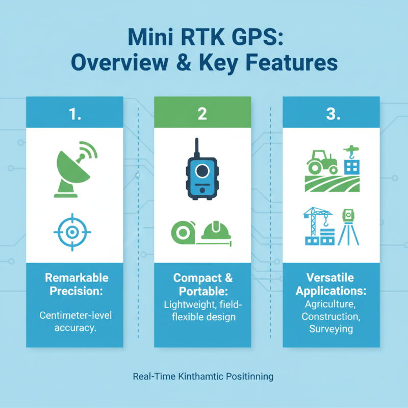
Mini RTK GPS: Overview and Key Features
Mini RTK GPS technology has become a game-changer in the world of accurate positioning solutions. These compact devices offer real-time kinematic positioning with remarkable precision. They cater to various industries, including agriculture, construction, and surveying. Users no longer need bulky equipment to achieve centimeter-level accuracy. Mini RTK GPS units are lightweight and portable, enhancing flexibility in the field.
Key features of Mini RTK GPS include advanced satellite communication. These devices utilize signals from multiple navigation satellites to improve positioning speed and accuracy. They often come with long-lasting batteries, allowing extended operational time without frequent recharging. Some models even offer weather resistance, making them suitable for outdoor use in diverse conditions. However, potential users should be aware that the performance can be affected by urban canyons or dense foliage, which may obstruct satellite signals.
While the advantages are clear, challenges remain. Not every user is trained in deploying these devices effectively. A lack of understanding can lead to subpar results, highlighting the need for proper training. Therefore, it’s crucial to consider these aspects before integrating Mini RTK GPS into your workflow. Being informed allows users to maximize the benefits while acknowledging potential limitations.
Understanding RTK Technology in Positioning Solutions
RTK technology stands for Real-Time Kinematic positioning, a method that enhances the precision of GPS. This technology is vital in various applications, from surveying land to guiding autonomous vehicles. RTK achieves centimeter-level accuracy by using a base station and a rover. The base station receives signals from satellites and transmits corrections to the rover. This two-way communication is essential for accurate positioning solutions.
Mini RTK GPS systems have become popular for those needing compact, efficient devices. Their small size doesn't compromise accuracy. These systems can fit into drones, robots, and vehicles easily. Users often report the ease of setup and the quick connection to satellites. While most users experience excellent results, some may find challenges in areas with poor satellite visibility. Obstacles such as tall buildings or dense trees can affect performance.
Understanding the limitations of RTK technology is crucial. Users should be aware of the environment when deploying their Mini RTK devices. Although the technology provides high precision, certain conditions can hinder results. Awareness and preparation can address these issues effectively. Users should remain adaptable and consider alternate strategies for challenging environments.
Advantages of Mini RTK GPS Over Traditional GPS Devices
Mini RTK GPS technology offers significant advantages over traditional GPS devices, particularly in terms of accuracy and efficiency. These compact systems provide centimeter-level positioning, which is crucial for applications like surveying and precision agriculture. This level of precision is often unattainable with standard GPS. Users frequently report improvements in productivity due to the accuracy provided by Mini Gnss Rtk systems.
In addition to accuracy, Mini RTK GPS devices are often more portable and easier to use. Their smaller size means they can be used in tighter spaces where traditional units struggle. This portability allows for more flexibility in fieldwork. However, adapting to the technology can prove challenging for some users. There's a learning curve as individuals familiarize themselves with the features and settings.
Another consideration is the reliability of satellite signals. While Mini RTK GPS generally performs well in open areas, signal degradation can happen in urban environments or dense forests. Users need to be aware of these limitations. Using Mini Gnss Rtk devices requires ongoing assessment and adaptation to maximize their benefits in various scenarios. This highlights the importance of user experience and the need for training to develop expertise in utilizing these advanced positioning solutions.
Why Choose Mini RTK GPS for Accurate Positioning Solutions? - Advantages of Mini RTK GPS Over Traditional GPS Devices
| Feature | Mini RTK GPS | Traditional GPS Devices |
| Accuracy | Centimeter-level accuracy | Meter-level accuracy |
| Size | Compact and lightweight | Bulkier and heavier |
| Setup Time | Quick setup with minimal training | Longer setup and calibration period |
| Power Consumption | Low power consumption | Higher power consumption |
| Real-time Data | Real-time data accuracy with GNSS | Delayed data accuracy |
| Cost | Cost-effective for high precision | More expensive for similar capabilities |
| Applications | Suitable for construction, surveying, and agriculture | Limited in high-accuracy applications |
Applications of Mini RTK GPS in Various Industries
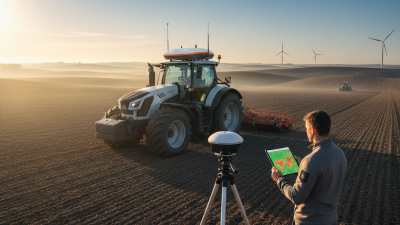
The Mini RTK GPS stands out in numerous industries for its versatility and precision. In agriculture, farmers use it to enhance planting accuracy. By effectively mapping fields, they reduce overlap and save resources. Drones equipped with Mini RTK GPS help in monitoring crops, providing timely data on health and yield. However, the initial setup may be time-consuming for some users.
In construction, accurate positioning is vital. Mini RTK GPS systems facilitate precise land surveying. This technology aids in laying foundations and installing utilities correctly. Despite its advantages, some challenges may arise. For instance, users must ensure unobstructed satellite visibility to achieve optimal results.
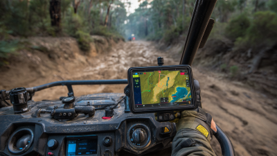
The logistics sector benefits significantly from Mini RTK GPS. Tracking shipments in real-time improves efficiency. Companies can accurately forecast delivery times. Yet, potential connectivity issues could hinder performance. Industries must weigh the benefits against possible setbacks, seeking continual improvements. Overall, Mini RTK GPS is transforming operations across various fields.
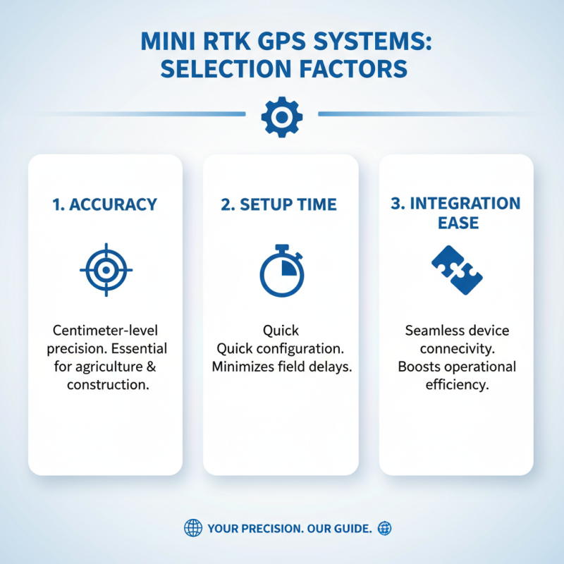
Factors to Consider When Choosing Mini RTK GPS Systems
When selecting a Mini RTK GPS system, several factors come into play. Accuracy is paramount. Look for systems that offer centimeter-level precision. This ensures your positioning solutions stand out in various applications, from agriculture to construction. In addition to accuracy, consider the setup time. Some systems require extensive configuration. The ability to easily integrate devices can also be crucial for efficiency.
Another important aspect is the battery life. Extended use in the field demands a reliable battery. A short lifespan can lead to interruptions. Evaluate the operating range, as this can affect usability in different environments. Poor signal can hinder performance, so reliable connectivity with base stations is essential.
Tips for choosing the right Mini RTK GPS include comparing the features of different systems. Read user reviews to gauge reliability based on real experiences. Look for systems with robust support options. This ensures you can get help when needed. Always assess whether the system meets your specific needs, especially if projects vary significantly.
Comparative Analysis: Mini RTK GPS vs. Other Positioning Technologies
In recent years, positioning technologies have evolved significantly. One standout option is the Mini RTK GPS. It offers precise location data, outperforming traditional GPS in various applications. According to a report from the International Journal of Spatial Data Infrastructures Research, Mini RTK systems can achieve accuracy within 1-2 centimeters. This precision is vital in fields such as agriculture, surveying, and drone navigation.
When compared to other positioning technologies, Mini Rtk Gnss highlights both advantages and limitations. For instance, traditional GPS solutions provide standard accuracy but lack the detail necessary for intricate projects. Conversely, while Mini RTK requires a stable base station connection, which can be seen as a drawback, the benefits often outweigh this challenge. A notable study from the Journal of Navigation indicates that Mini RTK systems significantly reduce post-processing time, a critical factor for professionals needing timely data.
Looking at satellite-based augmentation systems (SBAS), the accuracy of Mini RTK GPS emerges as a key differentiator. SBAS typically offers positional accuracy of about 1 meter, making it less suitable for high-stakes projects. It’s essential to weigh the trade-offs. Mini RTK GPS excels in high-precision environments, but potential users must consider the infrastructure needed for optimal performance. Understanding these differences is crucial for choosing the right technology.
Comparative Analysis of Positioning Technologies
Future Trends in Mini RTK GPS Technology and Its Impact
The rise of Mini RTK GPS technology is transforming the landscape of positioning solutions. Industry reports indicate a projected annual growth rate of 15% in the miniaturization of GPS devices. This rapid development presents opportunities and challenges alike. As these devices become more compact, their accuracy continues to improve, making them invaluable in various sectors such as Agriculture, Construction, and Surveying.
One notable trend is the integration of advanced algorithms to enhance positioning accuracy. For instance, studies show that Mini RTK GPS can achieve centimeter-level precision, which is crucial for tasks like land surveying and precision farming. However, this technology also raises concerns about its reliability under challenging conditions, such as urban settings with tall buildings. The practicality of using devices like the Leica Mini Prism highlights the need for continuous innovation to address potential shortcomings.
Moreover, the future of Mini RTK GPS will likely see better connectivity solutions, such as 5G integration. This change could drastically reduce latency and increase robustness in data transmission. However, as the technology evolves, ensuring data security and integrity will remain a critical consideration. Adapting to these new trends will require careful evaluation and a commitment to research in the field to maintain the advantages that Mini RTK GPS offers.
Essential Features and Benefits of the Portable Aluminum Apeks Apt4A Tripod with Auto Level Theodolite for Precision Surveying
The Portable Aluminum Tripod equipped with an Auto Level Theodolite is an essential tool for precision surveying, providing accuracy and reliability in data collection. One of the standout features of this tripod is its lightweight aluminum construction, which allows for easy transportation without sacrificing stability. This portability makes it ideal for professionals who need to set up surveys in various locations quickly. Additionally, the auto-leveling feature ensures that the instrument is perfectly aligned, eliminating human error in measurements and enhancing the efficiency of the surveying process.
Another significant benefit of this tripod is its adjustability. With multiple height settings, it can accommodate different types of terrain and user preferences, ensuring optimal viewing angles for surveying tasks. The robust design also withstands challenging environmental conditions, making it suitable for both indoor and outdoor use. By combining these features, the tripod not only boosts productivity on-site but also yields precise results that are critical for construction, engineering, and mapping projects. The thoughtful design of this surveying tool truly meets the needs of professionals seeking reliable and efficient equipment for their daily tasks.
FAQS
: Mini RTK GPS technology provides real-time kinematic positioning and high precision in various industries.
Industries like agriculture, construction, and surveying benefit from the accuracy and portability of Mini RTK GPS devices.
Key features include advanced satellite communication, long-lasting batteries, and weather resistance.
Mini RTK GPS offers centimeter-level accuracy, outperforming traditional GPS, which lacks detail for complex projects.
Challenges include the need for proper training and potential performance issues due to urban canyons or dense foliage.
Many Mini RTK GPS models are weather-resistant, making them suitable for diverse outdoor conditions.
Without proper training, users might achieve subpar results, limiting the device's effectiveness and potential benefits.
It requires a stable base station connection, which can be a drawback in certain environments.
It significantly reduces post-processing time, which is crucial for professionals needing timely data.
Users must consider the necessary infrastructure for optimal performance and potential environmental challenges.
Conclusion
Mini RTK GPS technology offers precise positioning solutions that enhance accuracy in various applications. This compact system incorporates Real-Time Kinematic (RTK) technology, which significantly improves the performance of traditional GPS devices. With its ability to deliver centimeter-level accuracy, Mini RTK GPS serves a wide range of industries, including agriculture, construction, and surveying, where precision is crucial.
When selecting a Mini RTK GPS system, several factors should be considered, including accuracy, ease of use, and compatibility with existing technology. Additionally, a comparative analysis of Mini RTK GPS against other positioning technologies highlights its advantages, such as quicker data processing and better reliability. As technology advances, the future of Mini RTK GPS looks promising, with innovations likely to further enhance its capabilities and broaden its applications across different fields.